The holy land of wise scholars, men of valour and courage blessed with the green
valleys,
hills and hillocks and inhabited by people known for innovative farming is being
divided,
to find the formation of Krishnagiri district carved out of Dharmapuri district as
30th district of Tamil Nadu.
'Krishna' refers to 'Black' and 'giri' refers to 'hill'. This district is gifted
with black granite hillocks and named as "Krishnagiri".
The region came under the rule of Krishna Deva Raya and hence it might have been
named after this king. Krishnagiri district is bounded by Vellore and
Thiruvannamalai districts in the East, Karnataka state in the west, State of Andhra
Pradesh in the North and Dharmapuri district in the south.
Total Geo. area : 5143 sq.km Elevation : 300 m to 1400 m. Location : 11° 12' N to 12° 49' N Latitude, 77° 27' E to 78° 38' E Longitude Avg. Rainfall : 830 mm per annum. Summer season : March - June Rainy season : July - November Winter season : December - February Soil type : Red sandy, black sandy and loamy
SOIL TYPES OF KRISHNAGIRI DISTRICT
| S.No | Taluk | Soil Type |
|---|---|---|
| 1 | Uthangarai | Dark reddish brown, Sandy clay loam |
| 2 | Potchampalli | Dark reddish brown, Sandy loam |
| 3 | Krishnagiri | Grayish brown, Sandy loam and clay loam |
| 4 | Hosur | Dark reddish brown, Sandy loam |
| 5 | Denkanikottai | Dark reddish brown, sandy and clay loam |
LAND USE PATTERN
The total geographical area of the district is 5.14 lakh ha, of which net sown area accounts for 35.03 per cent. The area under forest accounted for 39.35 per cent. Fallow and current fallow lands account for less than 5 per cent in the district.
IRRIGATION PATTERN
In Krishnagiri district wells and canals are the major sources of irrigation contributing to 81.19 and 10.71 per cent of the total area irrigated of the district respectively. Tanks accounted for less than five per cent.
| Revenue Divisions | Revenue Taluks | Panchayat Unions | |
|---|---|---|---|
| Krishnagiri | Krishnagiri | Kelamangalam | Krishnagiri |
| Hosur | Hosur | Thali | Kavaripattinam |
| Pochampalli | Hosur | Bargur | |
| Uthangarai | Shoolagiri | Mathur | |
| Denkanikottai | Vepanapalli | Uthangarai | |
| Schoolagiri | |||
| Bargur | |||
Local Bodies
Municipalities : 2 Panchayat Unions : 10 Town Panchayats : 6 Village Panchayats : 333 Revenue Villages : 661
ROAD TRANSPORTS
This district is connected by Prime Minister's Golden Rectangle Project executed by National Highways Authority of India. This district has a network of National Highways converging.
NH - 7 (Kanyakumari - Kashmir)
NH - 46 (Chennai - Bangalore)
NH - 66 (Pondicherry - Bangalore)
NH - 207 (Sarjapur - Bagalur - Hosur)
NH - 219 (Krishnagiri - Kuppam)
Apart from this state highways and district highways are linking almost all the towns and villages of the district. Four National Highways converge at the Head Quarters of this district is unique.
NATURAL RESOURCES
Krishnagiri is one among the districts of Tamil Nadu, which with natural resources having 2,024 sq.kms. of forest cover is its unique feature. The hill ranges of this district are called by the name 'Melagiri'. The major type of forest seen here are Tropical, Deciduous forests, thorny shrubs and bamboo forest. Dense forest cover Denkanikottai region. The other region contains shrubs, hills and hillocks with bushes.
MINERALS AND INDUSTRIES
"Paradise" is the most popular multi coloured granite available in Krishnagiri. Black granite is available in Hosur and Denkanikottai. Granite processing units, which make slabs of granite, finished and decorated beautifully is located mainly in Hosur surroundings. The multi coloured paradise slabs are being exported to America, England, Australia and some other European countries in large quantities. This industry is flourishing with the uninterrupted supply of electricity and availability of raw material and land at cheaper rates. A variety of quartz stones from Denkanikottai and White metal called Limestone from Uthangarai are mined.
RIVERS
The main rivers that flow across the district are Kaveri and South Pennar Kaveri enters the district from South West in Denkanikottai taluk and exists in South West direction. It forms a waterfalls at Hokenakkal and joins Mettur Dam. South Pennar originates in Nandidurg of Karnataka and flows through Hosur, Krishnagiri and Uthangari taluks. Vanniyar and Markanda rivers join this South Pennar.
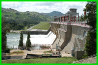
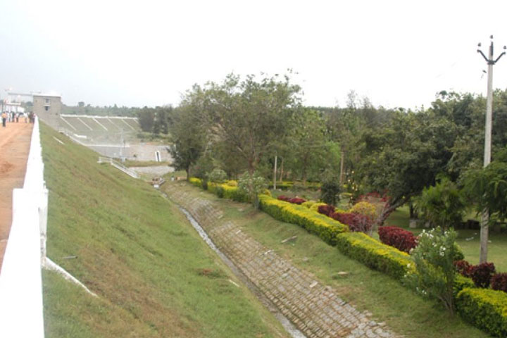
RESERVOIRS
Krishnagiri Reservoir Project, Shoolagiri-Chinnar Reservoir, Thangarai Reservoir, Pambar Reservoir, Kelevarapalli Reservoir project and Baarur Tank are the sources of irrigation for our district. By all these water reservoirs 18,965 ha. of land is irricated.
REGIONAL RESEARCH STATION (RRS)
Regional Agricultural Research Station of Tamil Nadu Agricultural University is functioning efficiently at Paiyur in Kaveripattinam union since 1973 AD. This station is functioning in 18.5 hec. of land. It helps the peasants to develop and adopt the modern technique of cultivation. It has developed hybrid seeds by research which yields more tonnage and good quality.